

Fog of World alternatives: six apps that map where you've been
Fog of World is the original fog-of-war travel map: the world starts covered and clears wherever you go. It has been around since 2012 and is a paid app. If you want a free app, street-by-street detail or friends to compete with, one of these six may suit you better.
We make StreetPainter, so it comes first and is marked as ours. Everything about Fog of World and the other apps comes from their Google Play listings, App Store pages and websites, checked on 3 October 2026. For Fog of World that is its Google Play listing and fogofworld.app.
Three ways to map the same walk
Before comparing features, check what each app counts as visited. The same walk through the same streets ends up as a very different map.
Area fog
A circle around you clears as you move. Passing near a street is enough.
Fog of World, Fogbreaker
Painted streets
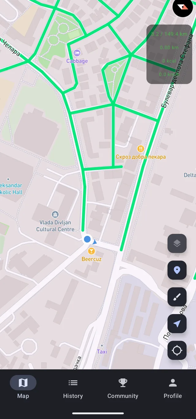
Only the street segments you walked fill in. The street next to yours stays dark.
StreetPainter, CityWalker, CityStrides, Wandrer
Map squares
The map is a fixed grid. Touching any part of a square counts the whole square.
Squadrats
Every Single Street: which apps fit
Every Single Street is a challenge to run or walk every street in a city. Ultrarunner Rickey Gates started it in San Francisco in the fall of 2018 and covered more than 1,100 miles of streets in 46 days, as Strava's guide to the challenge tells it. Many runners and walkers have since taken it on in their own towns, often under the #everystreet tag.
For this goal an app has to count individual streets. Area fog and map squares mark a street as done when you only passed near it, so they cannot tell you which streets are still left.
- StreetPainter
- Records the walk itself and paints each street segment as you go, so you can see during the walk which streets are still dark.
- CityWalker
- Shows street coverage per city and plans routes through the streets you have not walked yet.
- CityStrides
- Made for this goal: it counts completed streets per city from Strava, Garmin and other trackers.
- Wandrer
- Scores distance on roads you have never been on. Strava's guide suggests it for finding the streets you still have to cover.
StreetPainter
Our appBest for painting every street you walk, with quests and friends.
StreetPainter records your walk with the phone's GPS, matches the trace to OpenStreetMap streets and paints the segments you actually covered. A street you only passed nearby stays dark. Kilometers add up by city, region and country.
On top of the map sit quests, XP and levels, discovery points, friends and leaderboards. Walking, cycling and car modes each get their own speed limit, so a drive does not count as a walk. After a walk you can watch it replay as its streets paint in again.
- Platforms
- Android. iPhone waitlist
- Records
- Its own GPS, in real time
- Maps
- Streets, with km by city, region and country
- Cost
- Free, no ads. Optional Premium subscription
Good at
- Paints the exact streets you walked, not a radius around you
- Quests, levels and discovery points give each walk a goal
- Replays a walk as the streets paint in, and shares it as a GIF
- Friends and leaderboards; friends' routes show on your map for free
- Painting, quests and leaderboards are free, with no ads
Keep in mind
- Android only for now
- No import of old tracks: only walks recorded in the app count
Fogbreaker
Best for a fog-style map that is free to download, with levels and a step goal.
Fogbreaker is the closest to Fog of World's idea. It clears fog in a radius around you and shows how much of your country, region, city and neighborhood you have uncovered. It also works as a step counter.
XP, ranks and levels widen your reveal radius over time. There are one-use items, a friend leaderboard and a daily step goal.
- Platforms
- Android, iPhone
- Records
- Its own GPS and step counting
- Maps
- Area fog, with % down to neighborhood
- Cost
- Free. Ads and in-app purchases
Good at
- Same fog-of-war idea, free to start
- Levels change how much of the map you reveal
- Friend leaderboard and a daily step goal
Keep in mind
- Does not paint streets: it clears an area around you, so you cannot see which streets you walked
- Google Play lists ads and in-app purchases
Checked on Google Play and fog-breaker.com, 3 October 2026.
CityWalker
Best for free street coverage and importing old GPX files.
CityWalker builds street-level coverage from OpenStreetMap and shows a percentage for each city and region. It records with its own GPS and can import GPX files from Strava, Garmin or Komoot.
A route planner points you at streets you have not walked yet, and you can mark streets done by hand.
- Platforms
- Android, iPhone
- Records
- Its own GPS, plus GPX import
- Maps
- Streets, with % by city and region
- Cost
- Free, no ads
Good at
- Street-level coverage, free and without ads
- Imports old tracks from GPX files
- Plans routes through streets you have not walked
Keep in mind
- No game layer: no levels, quests or friends
- Built around one city at a time rather than travel
Checked on Google Play and citywalker.app, 3 October 2026.
CityStrides
Best for runners and walkers who already log everything on Strava or Garmin.
CityStrides is a website, not a phone app. It pulls in activities from Strava, Garmin, Polar, Coros, Suunto and other trackers, and counts how many OpenStreetMap streets you have completed in each city.
Leaderboards, badges and the LifeMap of everything you have done are free. Challenges and route tools come with the paid Supporter plan.
- Platforms
- Web
- Records
- Imports from Strava, Garmin and others
- Maps
- Streets, with completion per city
- Cost
- Free. Paid Supporter plan
Good at
- Uses your whole history from many trackers
- Big community and city leaderboards
Keep in mind
- No phone app: Strava, Garmin or another tracker has to record the walk
- Progress shows up only after the activity syncs, not during the walk
Checked on citystrides.com and pricing, 3 October 2026.
Wandrer
Best for cyclists who want points for every new road.
Wandrer syncs rides and runs from Strava, Garmin and RideWithGPS and scores the distance you cover on roads you have never been on, from town level up to country.
It has achievements, a leaderboard and monthly and yearly challenges. It runs in the browser, and there is an app for Hammerhead Karoo bike computers. An iPhone app is in beta on TestFlight, announced in Wandrer's April 2026 update.
- Platforms
- Web. iPhone app in beta
- Records
- Imports from Strava, Garmin, RideWithGPS
- Maps
- New roads by distance, town to country
- Cost
- Free. Paid subscription
Good at
- Made for long distances and cycling
- Works with bike computers
Keep in mind
- No Android app
- The iPhone app is still a beta
Checked on wandrer.earth and the April 2026 update, 3 October 2026.
Squadrats
Best for collecting map squares instead of streets.
Squadrats splits the map into a fixed grid. Every square you pass through counts, and smaller squadratinhos, 64 to a square, reward local detail.
Most activity comes in from Strava, and the app can also record its own expeditions. Standings and the übersquadrat, your largest solid block of squares, keep it competitive.
- Platforms
- Android, iPhone, web
- Records
- Strava sync; can record in the app
- Maps
- Grid squares, region and travel scale
- Cost
- Free. Paid Pro tier
Good at
- On Android, iPhone and the web
- Works with your Strava history
Keep in mind
- Squares, not streets: crossing a corner counts the whole square
- Built mostly around Strava
Checked on Google Play and App Store, 3 October 2026.
Something here out of date? Write to contact@streetpainterapp.com and we will correct it.